Researchers from Fudan University, the University of Twente, and Chengdu University of Information Technology have developed a new dynamic parameter optimization algorithm that significantly improves the detection of soil freeze-thaw transitions from space. Published on September 10, 2025, in the Journal of Remote Sensing, this study addresses the challenges of accurately monitoring soil conditions, which are crucial for understanding climate patterns and hydrological cycles.
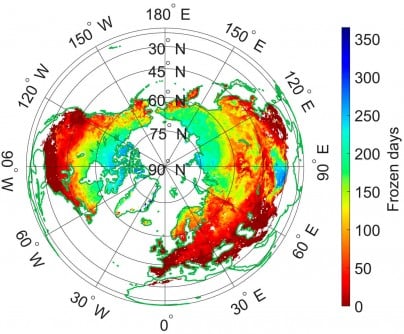
Freeze-thaw (FT) transitions in soil influence surface characteristics such as albedo, moisture, and heat fluxes, which in turn impact weather patterns. Traditional large-scale models often overlook diurnal soil temperature variations and surface heterogeneity, leading to inaccuracies. The newly developed algorithm utilizes L-band microwave remote sensing, known for its sensitivity to soil dielectric properties and its capacity to penetrate both snow and vegetation.
Previous algorithms, particularly those based on the Soil Moisture Active Passive (SMAP) satellite data, relied on globally fixed parameters. This approach proved inadequate across varied land cover and climate conditions. To overcome these limitations, the research team introduced a data-driven framework that adapts to local variations in terrain, climate, and land cover.
By enhancing the existing Diurnal Amplitude Variation-based Freeze-Thaw (DAV-FT) algorithm, researchers incorporated three dynamically optimized parameters—α, β, and γ. These parameters represent the detection period, variance window, and threshold sensitivity, respectively. The tuning of these parameters follows a method similar to maximum likelihood estimation, allowing for greater accuracy in classifying freezing and thawing states based on annual changes in L-band brightness temperature.
The results of this optimization were substantial. The overall classification accuracy (OA) in regions improved significantly, with the percentage of areas achieving an OA greater than 0.7 rising from 54.43% to 89.36%. The algorithm demonstrated particularly strong performance in regions such as the Qinghai–Tibet Plateau, southwestern Eurasia, and southern North America. Validation against ERA5-Land and SMAP-FT datasets further confirmed its reliability, achieving consistency rates of 81.28% and 79.54%, respectively.
In situ validation using 828 soil temperature stations established a median accuracy of 0.92, significantly surpassing both fixed-parameter and SMAP product accuracy. Dr. Shaoning Lv, the corresponding author of the study, emphasized the importance of this advancement. “The dynamic parameter optimization significantly enhances our ability to capture subtle soil freeze-thaw transitions that vary across regions and seasons,” he stated. He highlighted that this method not only refines the retrieval accuracy of L-band data but also leads to a more physically consistent understanding of land-atmosphere interactions.
The improved DAV-FT algorithm presents a robust framework for continuous soil freeze-thaw monitoring across diverse terrains. Its adaptability makes it particularly beneficial for high-latitude and mountainous areas, where existing algorithms often fall short. By accurately detecting soil states from space, this method enhances the capacity to assess permafrost dynamics, water availability, and land-atmosphere energy fluxes. These factors are critical for predicting the impacts of climate change and improving global land-surface models.
This research received funding from various sources, including the National Key R&D Program of China, the Key Research and Development and Achievement Transformation Program of Inner Mongolia Autonomous Region, and the National Natural Science Foundation of China. The collaborative efforts highlight the importance of interdisciplinary research in addressing global environmental challenges.
As climate monitoring becomes increasingly crucial in the face of global changes, this innovative approach to soil monitoring sets a precedent for future studies and applications in environmental science.