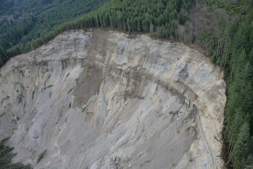
UPDATE: Washington State’s critical landslide risk mapping remains incomplete, more than a decade after the devastating Oso landslide in 2014. As the region braces for a second atmospheric river this Sunday, crucial data on vulnerable areas is still unavailable, leaving many communities at risk.
The Oso landslide tragically highlighted major gaps in Washington’s preparedness for such disasters. Many residents were unaware their homes were in peril. In the wake of the disaster, lawmakers initiated a mapping project to inform the public and local governments about landslide risks. However, despite the urgency, the project is yet to be finalized, and essential risk projections are missing for much of the state.
As of today, Sunday, December 10, 2025, Western Washington is reeling from unprecedented flooding, affecting over 100,000 residents. Joe Smillie, spokesperson for the Washington Department of Natural Resources, emphasized the urgency: “It is a knowledge gap and something we are hoping to address.” The completion of the mapping relies heavily on funding, time, and manpower.
Since the Oso tragedy, the Washington Legislature has allocated at least $23 million for an elaborate geo-mapping portal that aims to document every landslide and assess statewide susceptibility. The Department of Natural Resources (DNR) has employed advanced lidar technology, mapping roughly one-third of the state and identifying 40,000 to 50,000 existing landslides. Yet, only select areas, including Pierce County and the Columbia River Gorge, have comprehensive risk data.
Kate Mickelson, who leads the state’s mapping efforts, acknowledged the challenges: “It’s an enormous undertaking, and we are ahead of most states.” However, the DNR has no clear timeline for completing this vital project. “It will take us many, many years based on the amount of landslides and steep terrain,” she added.
Despite advancements, experts like University of Washington landslide engineer Joe Wartman argue that the current mapping tools are insufficient. The best available resource is a national susceptibility map from the U.S. Geological Survey, which lacks the granular detail needed for local risk assessment. Wartman insists that understanding this risk is essential for public safety, stating, “There is a real advantage to knowing you are in a hazard zone.”
As the region prepares for another storm, the stakes are high. Mickelson urged residents to stay alert and utilize available resources, including online safety guidelines. “We have more rain coming,” she warned, underscoring the urgency of the situation.
Moreover, as officials in Skagit County assessed potential landslide risks in Concrete, DNR’s mapping technology faced outages, hindering their ability to provide timely information. While backup data was used to recreate necessary maps, the incident raises serious concerns about the reliability of the state’s emergency preparedness resources.
In a state still recovering from the effects of past disasters, the incomplete landslide mapping poses a significant risk. Experts stress that without comprehensive risk assessment tools, residents may remain unaware of their vulnerability during extreme weather events.
As heavy rains continue, urgent questions remain: When will Washington finalize its landslide risk mapping? And how many more lives must be affected before critical resources are fully allocated? The situation is dire, and immediate action is needed to ensure public safety in the face of an uncertain future.