GFS Model Projects Up to 10 Inches of Rain Across Tennessee, Kentucky, Missouri, and Arkansas
The latest midday GFS model run reveals a dramatic shift in Southeast weather, forecasting aggressive rainfall accumulations over the next 16 days. Areas spanning Tennessee, Kentucky, Missouri, and Arkansas could see totals reaching as high as 10 inches, potentially ending the long-running drought gripping parts of the region.
Forecasters are signaling a clear pattern change from the dry, quiet weeks of April, as storm chances increase starting this weekend and extending into early May. This shift to a much more active atmosphere raises hope that parched lands could finally receive meaningful relief.
Heavy Rainfall Bullseye Targets Mid-South and Central Southeast
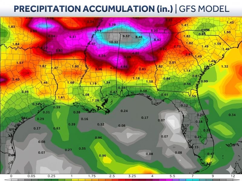
The GFS model highlights a concentrated “bullseye” of intense precipitation, with some local forecasts showing accumulations exceeding 9.5 to 10.3 inches over the 16-day period. Surrounding areas are also expected to receive between 3 and 6 inches of rain, with totals of 5.51, 5.05, and 4.04 inches forecast across adjacent parts of the region.
Significantly, rainfall totals drop sharply southward along the Gulf Coast, where less than 1 inch is expected during the same timeframe. This stark contrast highlights the intensity of the incoming pattern focused on the interior Southeast.
Drought Relief Possible as Storms Gain Strength
While meteorologists caution that long-range model projections often moderate as the event nears, the consensus is clear: a major atmospheric shift is unfolding. The increase in storm frequency and volume brings a real possibility of alleviating drought conditions that have plagued the Southeast for weeks.
“The directional shift from dry to active is credible and worth monitoring closely,” meteorologists report. Even if rainfall totals fall short of the GFS’s high-end estimates, multiple rounds of storms are expected to gradually improve the drought situation.
Active Storm Threats Arriving This Weekend
Forecasters also warn residents to prepare for strong storms beginning as early as this weekend. The unstable atmospheric setup fueling beneficial rainfall also raises the risk of heavy, potentially severe storms across parts of the Southeast.
Communities in Tennessee, Kentucky, Missouri, and Arkansas are urged to stay tuned to updated forecasts as precise timing and intensity details will sharpen in the coming days. The developing pattern could bring heavy downpours, localized flooding, and gusty winds alongside vital drought-ending rain.
What to Watch Next
As the Southeast braces for this crucial weather shift, experts emphasize the balance between hope and caution. The GFS model’s aggressive rainfall totals underscore the potential for rapid drought relief, but uncertainty about exact storm tracks and rainfall distribution remains.
Residents are encouraged to monitor local weather updates closely and take action as new forecasts emerge. This weekend marks the start of a critical period that could reshape the Southeast’s water outlook heading into early May.
Are you tracking the potential for drought-ending rain or preparing for weekend storms? Stay informed with continuous weather coverage at SaludaStandard-Sentinel.com to get the latest updates and safety guidance.