Giant 3.54 Inch Hailstorm Pounds Lake Amistad, Texas
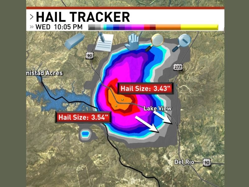
A powerful supercell thunderstorm unleashed giant hail measuring up to 3.54 inches in diameter over Lake Amistad, Texas Wednesday night at 10:05 PM, raising severe concerns for property and public safety as it moves southeast toward populated areas including Del Rio, Lake View, and Amistad Acres.
The storm’s massive hailstones, categorized as “giant hail,” pose catastrophic risks—capable of punching through vehicle roofs, shattering windshields, and destroying residential and commercial roofing systems. These conditions create a life-threatening environment for anyone caught outdoors during the storm’s passage.
Supercell’s Core Hail Zone Centered Over Lake Amistad
Data from the Hail Tracker system captured two distinct giant hail measurements within the storm’s core: 3.54 inches and 3.43 inches diameter hailstones. The intense hail core was located directly over Lake Amistad at the time of observation. The deep red and magenta colors in radar returns confirmed the concentrated hail production in the supercell’s updraft region, marking it as one of the most destructive hail events in the current severe weather outbreak affecting southern Texas.
Storm Advances Toward Del Rio and Surrounding Communities
The supercell tracked southeast from Lake Amistad, with its powerful hail core projected to impact the Del Rio urban corridor and nearby residential areas including Lake View and Amistad Acres. The wide area affected by smaller hailstones extending beyond the core zone indicates significant damage potential over a broad geographic footprint as the storm continues.
Local emergency services and weather officials warn residents in these communities to remain alert, secure property, and avoid outdoor exposure until the severe weather passes. The destructive potential of hailstones this size is considered exceptional, with the ability to inflict widespread damage in just minutes.
Back-to-Back Supercells Escalate Hail Damage Across Region
This supercell is one of at least two consecutive hail-producing storms tracked across the Lake Amistad and Del Rio area during the night. The repeated onslaught of large hail underscores an extraordinarily active and hazardous severe weather pattern impacting southwest Texas, amplifying concerns for cumulative property damage and public safety.
Communities are advised to stay tuned for ongoing updates as storm conditions evolve. The latest verified information and storm tracking are available at SaludaStandard-Sentinel.com.
Authorities urge residents to monitor local weather alerts, prepare for possible damage cleanup, and remain vigilant of any emergency instructions as severe weather activity continues across the region into the night.
“The size and intensity of this hailstorm present a serious threat to life and property, especially with the storm advancing toward populated areas,” said a local meteorologist monitoring the event.
This developing severe weather outbreak in southern Texas is a reminder of the destructive power nature can unleash with little warning. Immediate precautions are now critical for those in the storm’s path to avoid injury and minimize damage during this extreme hail event.